It is the perfect trail to walk with out of town guests who aren’t into the longer, higher, tougher trails locals are used to.
This pleasant link along the east shore of Cattermole slough joins oceanfront with town dike trails.
Its quiet aspect will likely return once construction on the Newport Beach oceanfront development site eases in a few years. In the meantime, walking along the trail provides a glimpse at the construction underway. The smooth, approximately 900-metre long trail follows the original paths from the first booming grounds to the village.
Prior to 1920, the fast flowing Mamquam River came down the present blind channel and this meant that log booms were best formed in the calmer waters of the estuary of the Squamish River.
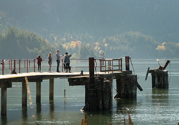
The tall piles and abandoned pier-heads are all that remains of this once busy booming and loading area.
Prior to 1958, when road and rail links were finally completed, the only way to get to Squamish was by water.
Until steamships were introduced in 1890, all travel was by canoe. The elders of the Squamish Nation still recall the long day of paddling to visit kin in Burrard Inlet.
Even the famous Judd piano, now residing in the Brackendale Art Gallery ( BAG), arrived by Indigenous canoe.
The railroad builders arrived in 1906 to start the northward link to the Interior. They constructed a long wooden pier from Nexen, now Newport, Beach south into deep water.
By 1914, this 400-meter long pier became the main point of entry, replacing Mashiter landing which was at the east end of present-day Winnipeg Street.
Coastal shipping flourished during the busy early years of logging and building railroads from 1890 to 1960. The Rail-Sail tourist excursion trip with the Royal Hudson steam engine and the Britannia ship kept the waterfront active until 1988.
Our maritime heritage continues today with increasing activity at Squamish Terminals and an active recreational boating scene, which are highlighted at the annual Windfest in July.
Having a deep water harbour with good rail and road links will keep our maritime heritage alive; expect more from the delayed, but still underway municipal Marine Strategy.
The Squamish Marine Action Strategy commenced in 2014 with the intent to mobilize shared leadership for the protection and increased use of the waterfront.
The first success was the removal of derelict vessels from the Mamquam Blind Channel in 2015/16.
Future marine industries are contemplated in the Newport Beach oceanfront development and these include a marine travel lift and associated repair shops to be completed over the next decade
Our District Official Community Plan (OCP) does align policy initiatives to support the maximization of the waterfront.
The goal is to retain a working waterfront that will add diversity to our economic base. A close second on this priority list is the need to protect and enhance the recreational aspects of the waterfront.
The slowly emerging Blind Channel pedestrian walkway will soon be a major attraction.
By softly mixing industry and recreation, it will be possible to maximize the clean use of our waterfront. Herring recovery work started by Squamish Streamkeepers in 2006 has produced much larger spawns. Years of benign ignorance about the effects of creosoted pilings came to an end when it was shown that covering the old pilings with environmentally friendly material did greatly increase the survivability of the spawned herring.
The thousands of old piles are the remains of 1890 to 1980 logging and booming operations. Allowing much more of the herring spawn to survive has brought back larger predators, with dolphins and orcas now common in Howe Sound. Lively photos of last year’s visiting orca pod may also be possible this year.


