The area west and north of Crumpit Mountain is a lovely series of rolling hills and open forest. This rocky area north of Valleycliffe is slowly becoming residential as new developments are built each year. Houses are encroaching from the west, Finch Avenue, and the south, Crumpit Woods. Developers have agreed to maintain trail connectivity, since access to outdoor recreational activity is a major reason for newcomers settling in our town.
Merrill and Ring logging swept through this area between 1916 and 1940. This train logging company completed the Valleycliffe area by 1926 and finished at Cat Lake in 1940. The company had bought all 10,500 acres in 1894, and it still retains some parcels of land in the Squamish area.
Many of the present trails are partially on old train beds. Some of the first recreational trails in this area were built by dirt bikers about 30 years ago. Conflicts with non-motorized users have been peacefully settled over the years. There is a working convention in place that all organizations have agreed to uphold.
Mountain bikers are now the more numerous participants in the Cougar Ridge and Crumpit Mountain areas. Hikers are well represented due to the fact that some viewpoints are only accessible on foot because of overly steep approaches. Horses are sometimes on the trails, so be aware of them.
The low elevation means that snow is rare and as a result, these trails tend to be in use year round. Signage is sparce and you must be prepared to navigate the myriad loops until you eventually emerge on a peripheral road.
The Coast Aggregates quarry/gravel pit at the eastern end of Centennial Way is a very active commercial site with lots of heavy equipment in daily use; stay clear of its signed limits.
Handsaw Hill on the western edge of this area overlooks Finch Creek. Below lies the ever-active gun club with its busy firing range, so stay clear of it too.
The new Legacy Park, funded by the Olympic Sports Legacy, is adjacent to the gun club. This enables the Nordic Club biathlon trainees to use the firing range. Squamish Rotary Club has just completed a fine shelter in Legacy Park for the flatland skiers and flyers.
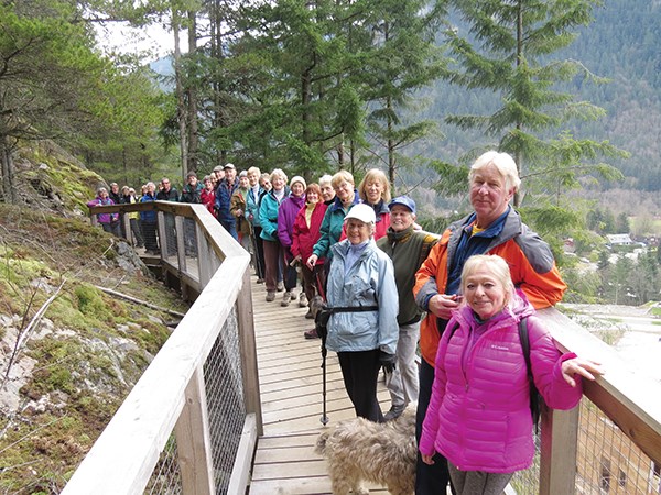
The seven hills in the Crumpit area can be linked in a variety of ways. The resulting hikes of up to five hours will present a good choice of fine viewpoints. The hiking trails to the summit of Crumpit Mountain are the second best hill climb in Squamish after the Stawamus Chief, and their steepness keeps mountain bikers away.
Local trail building ace Ted (Big Red ) Tempany and his Dream Wizards crew have been creative in building some of the trails in the Crumpit area. Specifically, their massaging of the Test of Metal routes has helped to popularize this iconic annual bike race being concluded this year.
Squamish people would have depended on the old cedar trees, forest plants and game in this area near their main townsite, Stawamus. Located on the banks of the Saw’7 elt – little river in the Squamish language – this site has been permanently occupied for thousands of years.
Parking is best done away from the residential streets. Overflowing vehicles cluttering home driveways annoy residents to the point of calling tow trucks. The SORCA shelter has only a few spots. There is easier parking available along the Stawamus Forest Service Road leading to the powerhouse.
These trails were built and are maintained by conscientious volunteers. You can help by donating time, material or money to the Squamish Trails Society, the Squamish Off-road Cycling Association, the Squamish Dirt Bike Association or the Squamish Valley Equestrian Association.
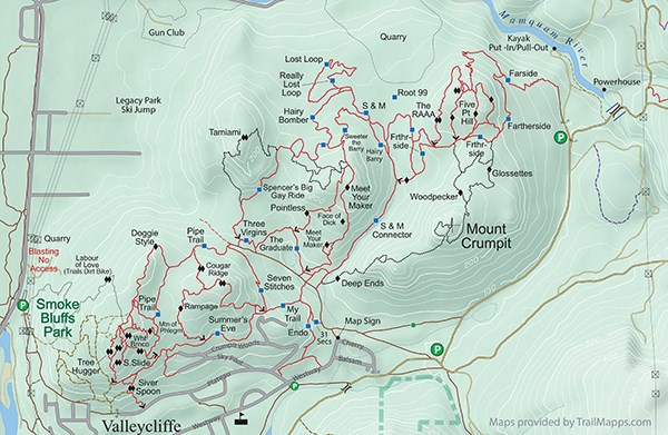
Crumpit hiking trails
This is an incredible network of hiking and biking trails in the area between Valleycliffe and the Mamquam River. Regardless of your ability, you will find a challenge on the many trails in the area of Crumpit Mountain area.
Origin of name: Crumpit is an English griddle cake that is small and round with a flat top, which does describe this small mountain. Some believe the name comes from How The Grinch Stole Christmas by Dr. Seuss; Mt. Crumpit is the high hill above Whoville where the Grinch lives near the town dump.
Trailhead: Northwest corner of Cherry Drive at Westway Avenue.
Use: Single track biking and hiking.
Difficulty: Moderate blue to black.
Elevation: 20 metres up to 308 metres.
Etiquette: Fast-moving bikers need to give early warning to slower trail users.


