Occupied by a campsite for more than 3,000 years, Fishermen’s Trail runs through a portion of Squamish Nation land called Kowtain Reserve #17.
Kowtain once included an area on the west side of the Squamish River that was swept away in a major freshet in the 1880s.
The present site, on the west side of Government Road at Garibaldi Way, has been threatened by floods, railroads and newcomers.
All who use this trail must respect the traditional rights of the Squamish people. It is not public land – it is the private land of the Squamish Nation.
The Squamish Nation has not ceded title to any portion of its traditional lands without a legal agreement.
The question of land ownership was first tackled by Gov. James Douglas in 1850 when the Crown bought land from local bands on Vancouver Island and allowed indigenous people to keep villages, enclosed fields and the right to hunt and fish on unoccupied land.
This policy was not continued on the mainland of B.C., with the result that indigenous people are still living with ambiguous legality.
In 1876, the new federal government assigned reserves on Squamish Nation land in an effort to smooth the arrival of newcomers and meet the just expectations of First Nations people.
Except for the 1913 forced railroad right of way, there was no formal transfer of ownership in this surrender of land. Treaties remain unfinished business in mainland B.C.
Fair fishing
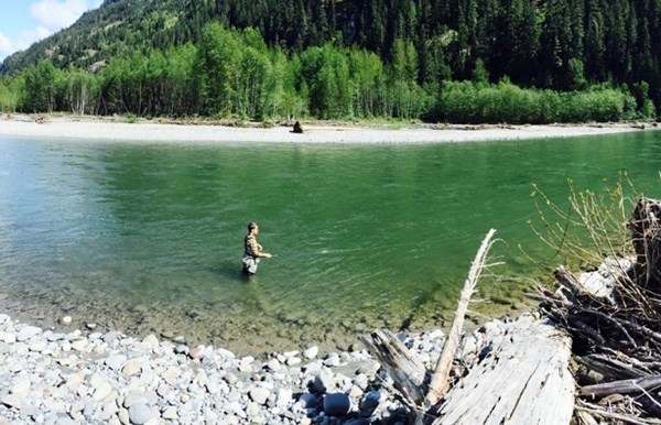
Squamish River is glacier fed from many distant icefields.
High water occurs often during periods of heavy rain and during freshet and the river remains silty at these times.
Best fishing is in late October. The river hosts late-running steelhead, chinook, coho, chum and pinks.
These fish travel to the many spawning and rearing streams and channels in the 355,000-hectare watershed.
Despite past abuses from tree cutting, logging roads and residential buildings, the Squamish River continues to offer fair fishing. Salmon take lures readily and can be caught on a variety of gear.
Fly casting is one of the most rewarding methods.
Chinook enter during late summer, followed by coho and pinks in late autumn.
No fishing is allowed in the Brackendale Eagle Provincial area just north of Kowtain where the migratory bald eagles have priority.
Sunwolf and Glacier Outback offer exciting raft trips and fishing adventures along the river.
Leski’s Crossing
Leski’s Crossing is the area around the railroad crossing on Government Road at the south end of Olson Road.
The Hop Ranch Farm was nearby and so was the site of Brackendale’s first school.
Carl Leski’s parents came from Poland before the Second World War and had a farm there from 1915 to the 1970s.
There are descendants living in our town: Kevin, Howe Sound Secondary grad of 1995, who was awarded a medal of bravery for rescuing two people from a burning car near Williams lake in 2007; Dennis was avid snowmobiler who died in an avalanche on Powder Mountain in 2012; and Richard, a young mountain bike racing star.
Sensitive habitat
Access to good fishing spots is getting scarcer each year as landowners object to garbage, dog poo, human waste and plants being trampled and terrain damage.
Not caring for the environment will lead to trail closures.
The sloughs and channels in this area are important rearing areas for juvenile fish because of high concentration of insects. Such environmentally sensitive areas must be treated with caution.
This means no garbage, no litter, no dumping and no damage.
We live in an especially beautiful part of the Sea to Sky Corridor, so lets all do out part to keep it that way so future generations can enjoy what we have.
See www.squamish.ca/esa-mapping for more information.
Fishermen’s Trail
Origin of name: Sports fisherman path to the river bank.
Trailhead: At Leski’s crossing on the west side of Government Road just west of the railway tracks.
Use: Single-track hiking
Difficulty: Easy green.
Elevation: 10 to 14 metres
Etiquette: Trail maintenance is ongoing and any small contribution is helpful.
Feedback: [email protected].


