Murrin Park Loop Trail
A relaxing stop along Highway 99 and some fine climbing.
Origin of name: In 1960, land for the park was transferred from BC Electric, the predecessor of BC Hydro. The longest serving company president was W.G. Murrin (1880-1961), who served as president from 1929 to 1946.
Trailhead: At the south end of the parking lot.
Use: Hiking, climbing, fishing and relaxing.
Difficulty: Easy green around the lake and moderate blue into the hills.
Elevation:100 metres to 165 metres.
Etiquette: Packing out your own garbage makes everyone’s experience better. Murrin Provincial Park is devoted to relaxing, picnicking, fishing, swimming and paddling. Locals and visitors have been coming here since the early 1900s, but many more arrived after the highway reached the area in 1958.
While climbers ease into the harder routes around Squamish from the new sites in this park, there are two delightful trails for all to enjoy.
The Murrin Park Loop Trail was completed in 2014 and is the culmination of Capilano University’s wilderness leadership program. The students, who were led by Brian Moorhead, a director of Squamish Access Society, built the trail over many days in 2013 and 2014.
The 1.8-kilometre loop leads to world-class climbing routes that have breathtaking views of Howe Sound devoid of any human effects. This loop does serve the climbers but is open to all. The older trail is a smooth 0.8-kilometre stroll around Browning Lake.
The lake takes its name from C.P. Browning, who was the general manager at Britannia Mine during the early 1900s. In 1920, he built a holiday cabin on the lake by boating in the materials to a rocky beach about one kilometre southwest of the lake.
Previously known as Phantom Lake, people soon began to call it Browning’s Lake and such it has remained.
The lake is regularly stocked with trout in the spring and autumn. It still manages to get fished out by keen amateurs.
The lake is rumoured to be bottomless, but this is not so. The depths have not been accurately measured at the centre because the artesian wells, which have water under pressure and flow naturally upward, move a bit.
The depths around the shore are 10 metres or less. The small lake is set up to cater to anglers who are still at the learning stage or who merely want to wet a line while relaxing. You still need a freshwater licence!
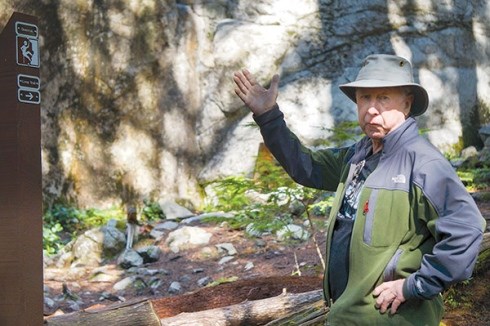
The rumoured collection of petroglyphs is merely that – a rumour. The only indigenous rock art in this park is one pictograph located about 50 metres northeast on the vertical granite, near a climbing route.
Petroglyphs are carved or scratched into stone, while pictographs are painted on with ochre. These historic artifacts are protected by the BC Heritage Conservation Act of 1997, which is an update of the Historic Objects Preservation Act of 1925.
This site is of cultural significance to the Squamish Nation and visitors should only view and not touch.
Better to see the modern example created by Xwalacktun (Rick Harry) in the Squamish-Lil’wat Cultural Centre located a bit north of our town.


