A potential landslide with enough material to fill B.C. Place twice poses an unacceptable threat to people living and working in Cheekye Fan area, experts say.
A Squamish Nation development proposal for approximately 200 acres of Cheekye Fan land is resurrecting the decades-old discussion regarding a potential debris flow from the area below Mount Garibaldi. Under the District of Squamish’s Official Community Plan (OCP), development within a large portion of the fan is prohibited until measures are put in place to deal with a potential slide, the municipality’s chief administrative officer Corien Speaker told council on July 15.
Squamish Nation officials hired BGC Engineering to examine potential risks and solutions. The district, Squamish Nation, and provincial government then formed an expert panel to review the report.
All the experts agreed on one thing — mitigation is needed.
Neither Canada nor British Columbia has a legislated level of acceptable risk when it comes to loss of life from a slide, BGC senior staff member Matthias Jakob said. The report recommended the district design hazard reduction infrastructure to withstand an event that has a one-in-10,000 chance of occurring or being exceeded in any given year — a .01 per cent chance. In doing so, the municipality would have to prepare for a worst-case scenario of a 5.5-million-cubic-metre debris flow, Jakob said.
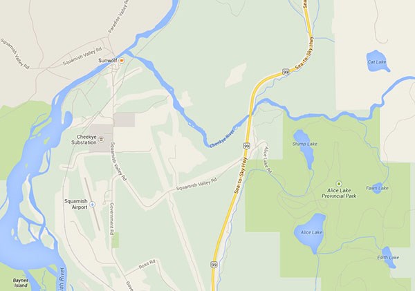
Small or large, sediment from a slide follows the path of least resistance, which in this case is Highway 99. A 5.5-million-cubic-metre slide would likely be up to 15 metres deep and travel at 10 to 15 metres per second, Jakob said.
The mud and rocks would likely dam the Squamish and Cheakamus rivers, causing flooding in the Squamish and Paradise valleys, he noted. While the flow may hit northern portions of Brackendale, the additional sediment could cause riverbeds to rise, causing flooding throughout Squamish, Jakob noted.
The report recommends a 35-metre-high damn be built in an area along the Cheekye River, uphill from Stump Lake. The natural “bath tub” would capture debris, Jakob said. Upstream from Highway 99, the engineering firm suggested a sediment basin be created to trap any overflow.
“Reliance on one structure only is probably not the best idea,” Jakob said.
Whistler’s economy could be hit hard by a slide that closes the highway. In the case of a large incident, road repairs could take weeks, if not months, Jakob warned. Whistler could experience economic losses equaling $1 million per day.
Council was asked to endorse the experts’ recommendation to accept their worst-case scenario and design future mitigation to those parameters.
District staff will come back with risk tolerance options. After a landslide in 2005 that killed one woman, the District of North Vancouver adopted a 1:100,000 risk tolerance criteria for new development — a .001 per cent risk of fatality of an individual per year exposed to the hazard. Last week, District of Squamish staff suggested council might want to do the same.
The big question lies in who will pay for the mitigation, Coun. Ron Sander said. He said he’d be surprised if the dam and sediment basin cost anything south of $100 million. No matter how that pans out, it’s good to see the issue addressed, he said, noting the limits on construction at the Squamish Municipal Airport have been sitting in limbo for far too long.
Mitigation would benefit multiple stakeholders, from protecting B.C. Hydro’s Cheekye substation to ensuring safety along the province’s highway and safeguarding the Sea to Sky School Board’s schools, Coun. Doug Race said.
“There may be opportunities to cost-share with some of these things,” he said.


