A new 70-kilometre hiking trail from Squamish to Port Mellon is now passable with some bushwhacking, as 43-year-old Vance Culbert discovered last week when he ran the route in 13 hours.
“At the moment [going on foot is] the easiest way to get through there,” Vance said.
“The trail isn’t in good enough shape yet to get bikes through. They still need a bit of work and some people out on either end to clear the trail a bit more before you can take a bike through it. So, until that is finished, running is the way to go.”
The trail connecting Squamish to the Sunshine Coast has been a labour of love for a small group of people in both communities for a few years now, headed by Geoff Breckner of Squamish.
Culbert’s 76-year-old father, Richard, has been involved for about a year working on the Sunshine Coast side, and for the past few months Culbert has been helping with some flagging of the higher sections as her father’s health hasn’t allowed him to make the trek.
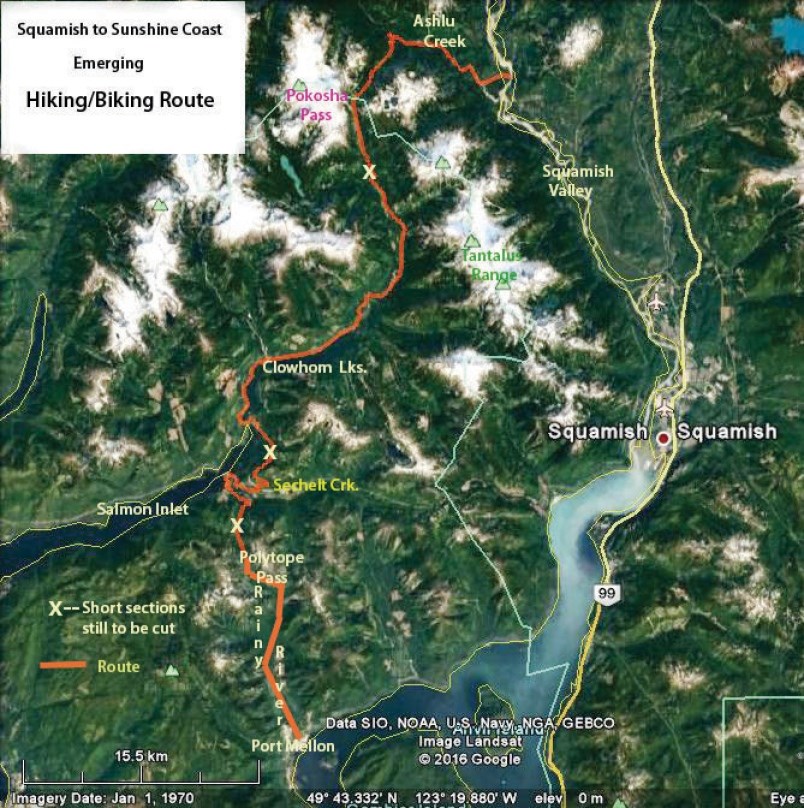
The trail comes from the Squamish Valley north of Squamish, where the only bridge across the Squamish River is along Ashlu Creek, up to Pokosha Pass, along Clowhom Lake across the head of Salmon Inlet, along Sechelt Creek to Polytope Pass and down Rainy River where it ends in Port Mellon.
The route makes use of existing trails, logging roads and hydro line rights of way, and volunteers have been putting in connector trails to link everything up.
Currently there are three sections that are passable only with some bushwhacking, so there’s still work to be done before the trail can be officially opened. But, armed with a compass and a good pair of running shoes, it’s doable.
On Aug. 12, Richard picked up his son on the logging road near Rainy River where the trail ends in Port Mellon, after he had completed the journey from the Squamish side in an effort to prove the route is passable.
“It’s a beautiful run,” Culbert said, noting the scenery is varied along the route that winds through different types of forests at various elevations, past pristine lakes, around mountainsides and over two mountain passes.
“You’ll see the back side of the Tantalus Range, which a lot of people don’t ever see.”
Richard was pleased to hear of his son’s journey and to get a first-hand account of how the route measured up on Aug. 12.
“It’s now certainly been shown that the route is viable,” Richard said.
The route as it stands now is close to completion; three sections, each under one kilometre in length, need to be cleared near Pokosha Pass, Sechelt Creek and Polytope Pass.
In the future, Richard said, “a lot of work is going to have to be done by parties out of the head of the Salmon Inlet who are willing to camp a couple of nights and put the trails in from that side.”
He is looking for volunteers who are willing to do the work and invites anyone who’s interested to contact him by email at [email protected]. People can also get involved and keep up to date with the effort by joining the group’s private Facebook page titled Squamish to Sechelt Trail.
The trail is meant to be a hiking/walking trail that will be accessible most of the year but closed in the winter due to snow at higher elevations.
Richard said anyone with dreams of making the trail into a roadway someday as a fixed link to the Lower Mainland is out of luck, as the mountain passes would take on too much snow and be too expensive to plow regularly.


