The heritage of the Sea to Sky Trail goes back to the beginning of indigenous settlement, as it’s likely that the first Squamish people found their way south into the Shining Valley about 9,000 years ago by following the Cheakamus River. Prior to 1854, when the barrier partially collapsed, this trail was the main trading link with interior First Nations. From 1855 to 1913, various entrepreneurs operated pack animals trains into the farms and camps around Alta Lake and Pemberton. There was even a wintertime dog sled link and one cattle drive in 1878.
The railway started in 1910 and the highway in 1956, both of which have used some of the old trail bed. Parts of this old trail bed are still visible near the railway line opposite the Cheakamus Centre (Spakmus in the Squamish language). Larry Wedge of Brackendale has also found some remnants under the powerline on the north side of the Cheekye River, and there are visible vestiges in the Brackendale Farmers’ Institute park.
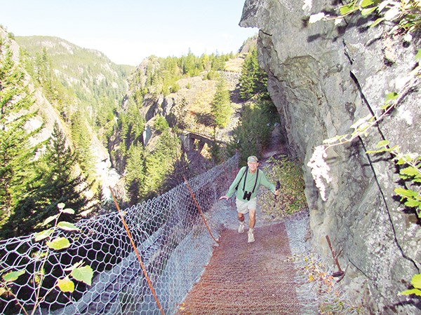
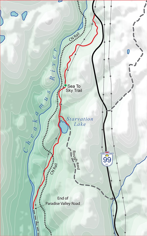
This long-range trail is coordinated by the Squamish-Lillooet Regional District on behalf of the municipalities and First Nations along the route. The leg of this trail south from Brandywine Park is very picturesque and travels through open second-growth forest by Reita Lake and the Black Tusk subdivision. From the Chance Creek Bridge, the trail follows the edge of Highway 99 until the Tantalus viewpoint, where there are picnic tables. Here, the trail drops off the west side of the highway toward Paradise Valley. This pea gravel section is steep at times and may be blocked by erosion and landslides. You will come to the unofficial railway crossing near the Cheakamus River and then follow the riverbank and rail line to the end of Paradise Valley Road. It is definitely “use at your own risk” along the railway right of way.
The damage to fish stocks caused by the train car spill of sodium hydroxide into the Cheakamus River on Aug. 5, 2005 was catastrophic. The massive cleanup effort, the passage of time and the diligent restocking efforts of the Tenderfoot Hatchery have brought back steelhead and trout. Tenderfoot Hatchery was built in 1981 and is open for viewing daily from 9:30 a.m. to 3 p.m. except when occasionally closed in August for operational reasons.
The spring freshet makes this river unsafe for paddling and unproductive for fishing from April to June.
Climbing routes exist below the Tantalus viewpoint off Highway 99.
Parking is sparse and remote at all locations along this section of trail. Do not leave anything visible in your vehicle. There is a fine camping and RV site at the Paradise Valley Campgrounds.
One question on my mind: Is the Jack Webster bridge near Culliton Creek named after B.C.’s famous radio broadcaster, and if so, why?
Sea to Sky North Trail #1
This section north of Brackendale offers pastoral Paradise Valley and strenuous wilderness beyond.
Origin of name: From sea water at Howe Sound to touching the sky at mountain tops near Birkenhead.
Trailhead: Nexen Beach (Newport Beach) with many access points along the trail.
Use: Single and double track, multi use.
Difficulty: Green (easy) to blue (moderate).
Elevation: In norther section, 40 metres to 360 metres.
Etiquette: Do not add cairns and unofficial signs – it only adds to confusion.


