A cooler-than-normal spring means high elevation snowpacks in B.C. are roughly double what they normally are this time of year, with the risk of flooding shifting to larger rivers like the South and North Thompson.
The BC River Forecast Centre issued flood watches on both arms of the Thompson River Friday morning as more rain is expected to fall on the snow lingering in the alpine.
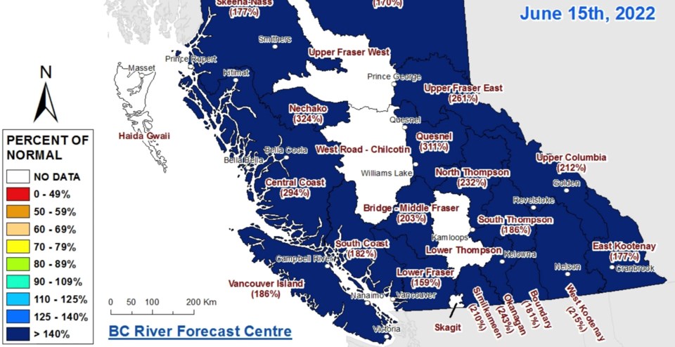
The North and South Thompson basins are reporting snowpacks of 232% and 186% of normal, respectively, according to new data released Thursday.
The Okanagan is reporting a snowpack of 243% of normal, but all but the highest elevation snow in the region has now melted. There are no high streamflow advisories or flood watches in the Okanagan or Similkameen, with the risk related mostly to rainfall.
"We've been having this dominant weather pattern of ongoing unsettled thundershowers, rainfall,” said Dave Campbell of the BC River Forecast Centre. “We saw earlier this week, places around Kelowna, Mission Creek that we're still very much susceptible and vulnerable to these heavy rainfall events”
Campbell says there is still a considerable amount of snow above 1,700 metres elevation. In the Mission Creek basin, there is a snowpack survey site at 1,800 metres that is only about half melted, which is keeping the creek full in between rain events.
He said inflows into Okanagan Lake, which hit full pool this week, are now “more or less” at their peak and should taper off in the coming weeks.
In Kamloops, Campbell said he’s uncertain when both arms of the Thompson River will peak.
“I do have continuing concerns that we could see additional rises through the Thompson systems,” he said. “We're in that period of high flows, and we're certainly vulnerable to additional rises, if we get adverse weather over the next week or two.”
Environment Canada says there is no sign of hot weather coming, so the flood risk will come from rain.
“It really is the rainfall side of things. So we're seeing quite a lot of precipitation potential. That could include areas in the Thompson, particularly in the North Thompson. We're watching for that,” Campbell said.
A significant thunderstorm is expected to hit Friday from east of the Okanagan to the Alberta border that could drop 20 mm of rain and hail.
Unsettled weather will continue throughout the Southern Interior through the weekend.
“Continued pulses of thunderstorm activity through Saturday and Sunday,” said Armel Castellan, warning preparedness meteorologist, Environment and Climate Change Canada.
Looking into next week and beyond, Castellan said things look cool in the short term, but will heat up in July.
“We don't see a signature for a big or strong heat event in the next couple of weeks. But the chances of seeing heat in July are obviously increased,” he said.


