It is not a stretch to say many locals are map-obsessed.
While maps are crucial tools for backcountry travel, they also have an inherent element of adventure baked into their topography; on one large sheet you can visualize all the places you want to go.
For local graphic artist Zoë Lomoro, they’re also rife with artistic possibility. “I thought the simplicity of some of them was nice—a de-cluttering, minimal approach,” she says.
Lomoro moved to Whistler six years ago and has been working as a graphic designer at Cutting Edge Signs ever since. But recently, she’s also been pursuing freelance work, her own art career, and a photography business.
“It’s going pretty good despite not having time to market myself,” she says, with a laugh.
Last year, she decided to add one more thing to her plate. “Everyone makes ski maps, but I thought it’d be cool to do bike maps,” she says. “I chose a few places and decided to draw them.”
She started biking—after some encouragement from her boyfriend, a former bike rep—when she moved to Whistler and while she says, “I’m not the best biker, but I’m fun to ride with,” it wasn’t hard to hone in on her favourite trails.
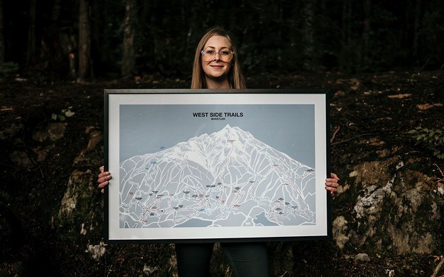
She started with Whistler’s West Side Trails before moving on to the South Side and the Mackenzie and Mosquito Lake areas of Pemberton. It turns out, drawing a map isn’t exactly easy.
“My maps are very perspective-based,” she says. “It’s valley-to-peak view. The Mosquito Lake area goes up and over the back of another mountain—you don’t see it from one vantage point. That was tough to draw.”
In the end, the three maps are stylistically similar with a minimal style, serene blue background, and colourful trails winding down familiar mountains.
The trails themselves are straight from Trailforks, so the map could be functional, but most people have hung them on their walls.
Lomoro’s only rule: no ruining any locals’ secrets.
“I won’t put anything on a map that’s not on Trailforks,” she says. “That would be terrible to ruin something. I’ll wait if I know a trail is going in.”
She first sold the maps at the State of the Art show in Creekside last December and January. And, currently, they’re for sale at Chromag Bikes in Whistler.
Soon, she plans to sell them on her website as well—and add a few more maps to the mix.
“I’m going to draw for Squamish,” she says. “I started with my favourites—just some places I’m familiar with riding.”
Lomoro also added environmental and social angles to the project as well. The map is printed on enviro uncoated paper (PSA: from working at a print shop, she knows not all paper is recyclable) and five per cent of all map sales are going towards athlete development.
For that she’s partnered with mountain bike athlete, trainer, and coach Katrina Strand to run a contest for a young athlete to win coaching, funded by the map sales. Coming up in May and June, the maps will also be featured in a show at Coast Mountain Brewing.
“The plan is to get more maps drawn, printed, and ready,” she says. “I thought this would be a cool way to give back in a different way.”
Maps are currently available at Chromag for $45 (cash only). They will also be for sale online at zoelomoro.com.


