The many stages of our town’s development, from First Nations and farming, forestry, transportation, manufacturing and now tourism, have all depended upon the estuary.
As it moves forward by adding a few centimetres of mountain sediment to the river mouth each year, so does our municipality gain and grow. Squamish people depended on the abundant fish and game of the estuary and had a village, Skwelwil’em, west of the present site of Castle Rock housing. The first farmer, George Magee, built levees with Chinese labour and drained the wetlands to provide hay for the oxen and horses used in early logging from 1890 to 1910. Forestry work gradually went inland and upland with logging railroads but still needed the estuary for booming and shipping. Manufacturing sites such as sawmills, a chemical plant and rail repair yards needed the flat land of the estuary.
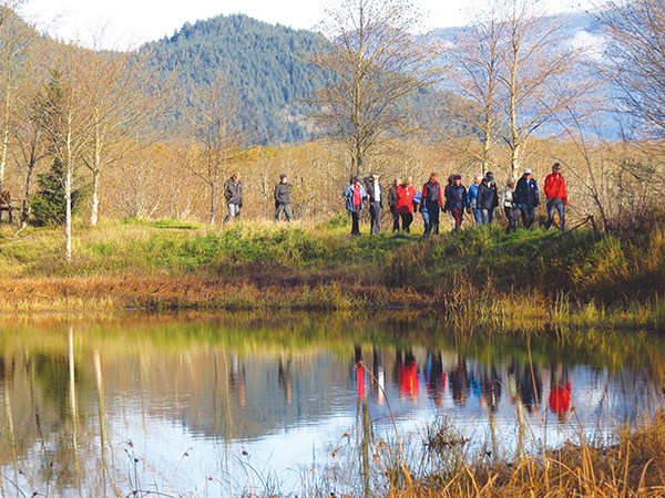
Tourism has grown with paddlers, kiteboarders, hikers and anglers all making good use of the estuary. The past and future of our town is inexorably linked to our estuary.
All stakeholders had agreed in 1982 that the land and waters west of the railway tracks would become a restricted conservation area. The resulting Squamish Estuary Management Plan has been in force since 1999. This plan is monitored by the Squamish River Watershed Society, which is committed to enhancing and preserving the integrity of this area.
Adjacent to the WMA are Site A and the TLC (The Land Conservancy) area. Site A, about 30 hectares of cultural significance, was transferred to the Squamish Nation in 2001 with a restricted covenant. The TLC site, about seven hectares acquired in 2008, is an ecologically significant area around Cattermole Creek. The marsh meadows, spruce and alders provide sanctuary to species at risk such as the Pacific water shrew, red leg frog and trumpeter swan. The estuary is also recognized as an Important Birding Area (IBA) and draws many avid birders anxious to see and hear the variety of birds, including the belted kingfisher, geese and crows.
The Spit Road was built in 1972 in preparation for a planned coal shipping facility. The goal, to train the river flow away from the pier, was successful and Squamish Terminals does handle large merchant ships with ease. The planned coal facility was cancelled due to public pressure and the Spit Road has become a boon for windsports. The Squamish Windsports Society regulates the safe use of the southern end of the spit, which vies with the Columbia River as the best windsports site in North America.
The estuary trails explore the tidal mudflats, marshes and wetlands. River freshwater mixing twice daily with tidal salt water creates a bountiful ecosystem. Roots and grasses filter the waters and the resulting brackish water has a high nutrient content – great feed for birds and fish and habitat for recently spawned salmon.
Several issues within the estuary area still need to be resolved: trail crossings on railway property, off-leash pets, trail maintenance within WMA and the looming Seventh Avenue Connector road planned for the area.
• Cattermole Creek Trail: 1.2 km going south from Bailey street along the southbound tidal stream.
• Chelem Trail: 1.1 km loop off Spit Road (also called the Marsh Trail). Chelem is the Squamish language word for eel grass.
• Old South Dike Trail: 1.2 km interrupted by washed-out bridges along the top of the old sewer line, which was permanently capped in 2000. Rooty and gnarly but popular with birders.
• Swan Trail South: 1.8 km going north from old log sort to the Mamquam River along the River Dike.
• Town Dike Trail: 1.9 km from Cattermole Slough north towards Bailey Street.
• Waterfront Trail: 1.0 km along the east side of Cattermole slough leading to Nexen Trail.
• Old North Dike Trail: 1.4 km from west end of Vancouver Street and sometimes called the North Loop or Blue Heron Trail.
• Woodpecker Trail: 1.4 km loop off Spit Road west of Dentville. As you guessed, woodpeckers are often sighted.
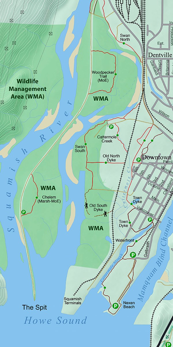
Estuary Trails
The trails through the historic tidal estuary are within the Wildlife Management Area, home to much flora and fauna. There are fine views of the surrounding snow-capped mountains, Stawamus Chief, Shannon Falls and Howe Sound.
Origin of name: dictionary meaning is “tidal mouth of a wide river.”
Trailheads: West end of Bailey Street and off Spit Road.
Use: Single-track, hiking, biking.
Difficulty: Easy/green.
Elevation: 1 to 3 metres above sea level.
Etiquette: Stay on the trail. Do not damage sensitive terrain.


