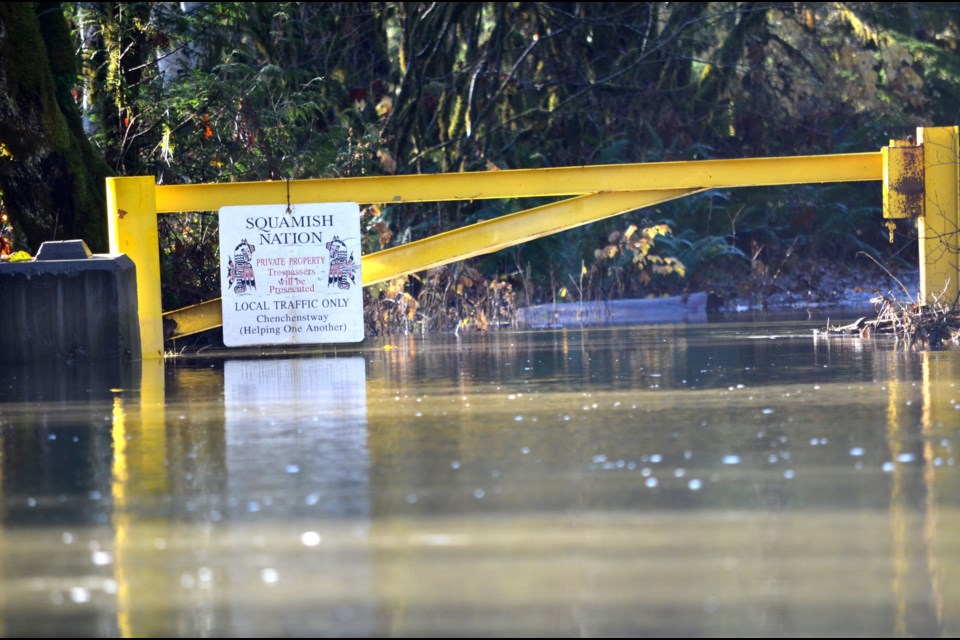
In the wake of a torrential rainstorm that swept through town, a Squamish Nation member says a “third river” formed in the Cheekye Reserve, or Cheakamus IR 11, in Paradise Valley.
“The river broke through under the hydro lines here, and started a new river right in front of — as everybody knows — Fergie’s Landing Road,” said Shirley Lewis, who works for the Nation’s fisheries department.
It was a local example showing the severity of Monday’s deluge of rainfall that caused flooding throughout the province.
Lewis was speaking on the phone on Nov. 16 while she was on the reserve investigating any potential damage to fishing grounds.
On Nov. 15, all of Squamish was engulfed in the storm. The weather event turned streets into streams, hiking trails into waterfalls and rivers into raging white-water rapids.
So how much rain was there?
Local meteorologist Jason Ross said that from 11 a.m. on Saturday to 4 p.m. on Monday, the measurements at the Squamish airport showed 206 millimetres of rain fell.
In Whistler, 121 millimetres fell, while Pemberton and the Callaghan Valley saw 94 millimetres and 119 millimetres, respectively.
Ross said the extreme weather was caused by an atmospheric river.
This phenomenon is a long, narrow band of moisture in the atmosphere that carries water from the tropics and subtropics toward the poles, he said.
“Atmospheric rivers carry about 90% of the water vapour that’s transported toward
the North and South poles across the mid-latitudes — in the Northern Hemisphere, that includes the south coast of B.C.,” Ross wrote to The Chief.
“Atmospheric rivers can carry massive amounts of water vapour, and when it collides with land, it releases tremendous rains that could last for days and trigger devastating landslides, floods, and fatal avalanches. Studies have shown climate change is making atmospheric rivers bigger and more dangerous.”
About 25 to 30 atmospheric rivers hit the B.C. coast each year, but this one appeared to be the wettest yet, he said.
“On Sunday, more than 20 Environment Canada locations across B.C. broke daily rainfall records, with Abbotsford, Chilliwack and Hope all clocking their all-time wettest 24 hours, areas like Hope and the Coquihalla Summit saw more than 250 millimetres of rainfall,” Ross said.
Squamish ReBuild
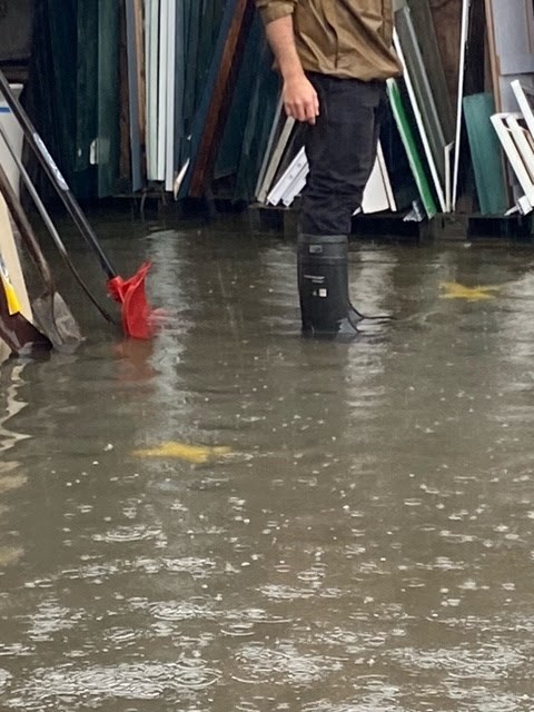
At Squamish ReBuild, a water-logging forced the facility to shut its doors on Nov. 15.
Shanda Dosanjh, the operations manager, said that water covered much of the inside of the facility, and eight inches of water submerged the main part of the yard.
“There's probably at least two inches in the store of water. So we're hoping to dry it out and not have to rip everything out,” Dosanjh said.
She added it was about eight inches deep in the main part of the yard.
As a result, Dosanjh wound up working late into the night to get rid of the water.
She eventually went home at around 3 a.m.
“Pumps and a little cursing” was the recipe for fixing up the building, she said with a laugh.
An overview
David Roulston, the District’s manager of municipal infrastructure, said there were no issues with the dike system observed during the storm.
He noted the weather event resulted in significant peaks on the major river systems running through town.
“In particular, the Stawamus River saw flows exceeding a one in 10-year return period. The river reached the elevation of Valley Drive leading into Valleycliffe, but did not exceed it and flooding was kept to a minimum. The river reached the bottom of the CN rail bridge at its peak, but no damage was sustained,” he said in a written statement.
“The Cheakamus River saw significant flows that reached just below a one in five-year return period. The river crested just below the height of Paradise Valley Road.”
The reference to one-in-10 or one-in-five periods measures the probability such a weather event will occur in a year. The rarer the event — like a one in 100 — the more severe it typically is.
Rouslton said that the Squamish River saw significant flows just below a one in two-year return period. All of the District’s drainage pump stations were operating and water levels in the sloughs and forebays were maintained to normal operating levels.
The Mamquam River reached a one in two-year return period storm, which resulted in flooding of some of the trail network along the river, he noted.
However, the deluge of rain has created slope stability issues along Mamquam Road, just below Quest University, and the public has been asked to stay away from that area until the slope can be assessed further, said Roulston. Conditions have since deteriorated significantly, and the District has closed the road to the public.
“Many creeks throughout town crested their banks which led to minor road flooding throughout town. Thankfully there was minimal damage to infrastructure,” he said.
Close call
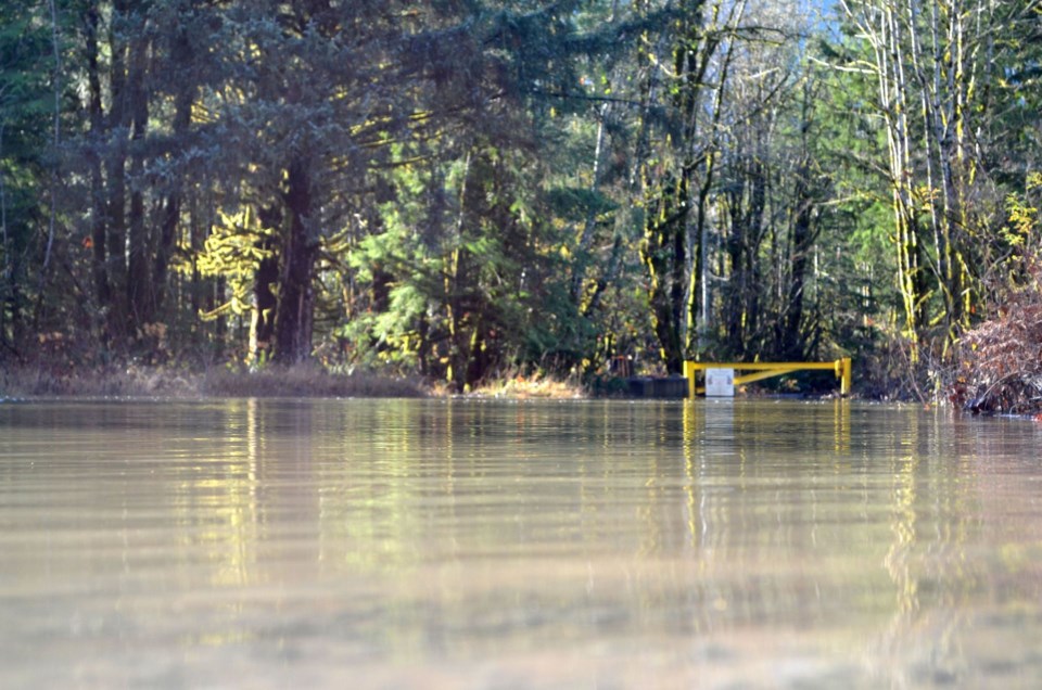
Back at the reserve on Tuesday morning, Lewis said that everyone on the reserve appeared to be safe, and property in the area didn’t seem to be significantly harmed.
On the road to Fergie’s Landing, the river appears to have receded 10 feet as of Tuesday morning, she said.
However, she noted, with water flowing through a new pathway, locals can’t get to their fishing grounds. Most of the fishing for the season is already done, but this blockage could mean Nation members won’t be able to enjoy the fruits of the chum salmon run that’s currently happening.
This batch of salmon is usually used smoked.
“This is the third big flood that’s come through our territory. The last one was in the 1980s and we had to get evacuated by helicopter back then,” Lewis said.
Leanne ‘Bird’ Lewis, a resident who lives in the area, said it felt like a close call.
“We’re grateful that water didn’t get here, because I know how many years ago our basement got flooded, and I’m really glad that it didn’t this time,” said Leanne, another member of the Lewis family.
She said community members on the reserve had their bags packed and ready to go.
“There is that worry of how much water is going to come in, how much damage is it going to do to the property,” Leanne said.
During the storm on Nov. 15, it luckily didn’t come to that — but it very well could have.
The Squamish-Lillooet Regional District issued evacuation alerts for Paradise Valley as rain pelted the area and river levels rose.
Residents didn’t end up leaving their houses, but they were being told that they could be forced to leave at a moment’s notice.
In the meantime, the District of Squamish issued a flood watch alert as water levels started to rise.
BC Hydro issued a spill notice for the Cheakamus River, warning that water levels could dramatically rise as a result of releases from its dam upstream.
Dan Lewis, who lives in the Cheakamus 11 Reserve and is another member of the Lewis family, said that everyone there appears to be safe. He noted water is seeping into some parts of the land, but, for the most part, properties were doing fine.
The reason for that was what he called a “horizontal stockpile” that was constructed about 10 years ago in the area.
It helped keep the floodwaters at bay, but Lewis said he’d like to see senior levels of government create an actual berm or dike to offer lasting protection from these kinds of events.
He also noted that this recent flood event likely raised the riverbed by several feet, as a result of the massive amounts of material being deposited by the rising waters.
“It hurts the salmon, it hurts the impact of the land, because the land gets pushed up and it starts finding all the lower areas to flow into,” said Dan.
“I’d like to see the river dredged out again and there’s got to be mitigation that needs to be in place by the government or the Squamish Nation government, or a combination or both.”
The director for Area D of the Squamish-Lillooet Regional District, which encompasses the valley, said that there were no indications of people suffering severe injury or of catastrophic property damage.
“If there had been any injuries or life lost, I’d know that for sure and I haven’t heard, so I’m confident in saying there wasn’t any,’ said Tony Rainbow.
“With regard to property, the last information I had was there was no significant damage at all. Again, if a house had been washed away or something, I certainly would’ve heard about it.”
He noted residents’ desire for better flood mitigation, and said that SLRD staff are studying flood mitigation possibilities.
A report detailing these findings is expected to come to the regional district board this month.
“If we get from there really strong recommendations that diking can be improved or whatever, then the SLRD has to pay attention to that,” Rainbow said.
However, the power to make the change isn’t in the SLRD’s hands alone — it will need considerable support from senior levels of government, such as the province, he said.
What does the province say?
The Ministry of Forests said in a written statement to The Chief that the province provides several mitigation funding programs that support First Nations and local authorities to plan, design and install structural mitigation works, including dikes.
However, it said the province does not directly install new dikes to protect communities.
“The province is working closely with First Nations, local governments and others to develop a BC Flood Strategy to provide a vision, principles and priority actions for a modernized approach to flood risk reduction and looks forward to continued engagement with communities on this,” the statement read.
The ministry also said many First Nation communities work with Indigenous Services Canada to initiate risk assessments, flood modelling and mapping, and mitigation planning through programs like First Nation Adapt or through capital programs for dike construction on reserve.
A little joy in the rain
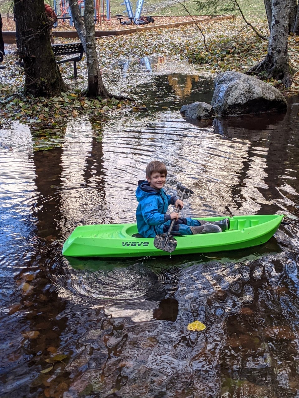
The rain wasn’t a stressful experience for everyone.
Heath Tappin, a local five-year-old who lives in the Garibaldi Highlands, noticed on his way to school that a ditch on Ayr Drive had been turned into a small lake.
“The water was coming way up to the tires [of my car],” said his mother Nina.
“He really, really wanted to kayak. He was thinking about it all day.”
It was the perfect opportunity to give Heath’s child-sized kayak a chance to navigate the newly-formed body of water.
Later, when school ended, they headed back with the vessel in tow, and Heath was able to paddle to his heart’s content.
“I wanted to kayak. I thought about kayaking, so I asked Mom if I could kayak, and she said yes,” Heath said.
“I just thought it was the cutest thing ever,” his mother said.
Nina said it was a good opportunity to bring the watercraft out of the garage, as it hadn’t seen any action since summer. Heath had received the boat earlier this year after having it on his wish list for some time.
Heath said that his favourite part was “cruising across the water” with “the wind billowing on [his] face.”


