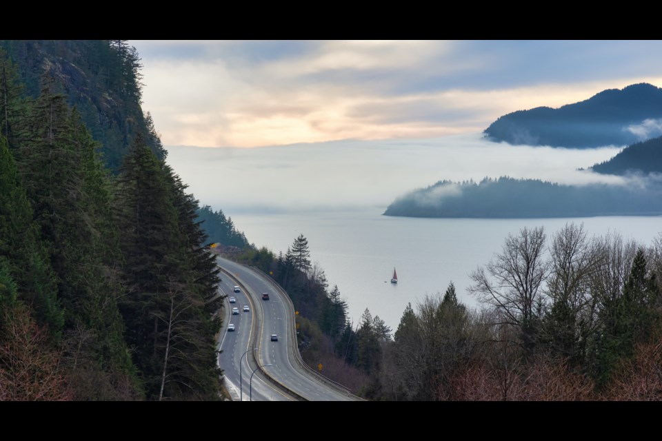
Anyone who lives in the region or has ever travelled it has an opinion on that scenic stretch of road between Lions Bay and Whistler, but what does a person who studies such things think of the Sea to Sky Highway?
Suliman A. Gargoun, an assistant professor of civil engineering at the School of Engineering at the University of British Columbia (UBC), says he sometimes heads up the Sea to Sky Highway just for the opportunity to drive the road.
Unsurprisingly, he likes the views but also enjoys taking the curves from behind the wheel, he said.
"It's a beautiful highway," he said, adding that he would rank it as one of the more challenging ones from a design perspective.
He noted the challenge of designing a highway like this is the constraints of the mountains, which create many dilemmas.
"How do you cut through the mountains to create that road?"
The railway line also presents its own issues.
"You want to minimize the earthmoving that's going to go on — the cut and the fill. But at the same time, you don't want the driving experience to be too challenging. You want to design the curves in a way that you can maintain 'highway speed.' So, at least 70 kilometres an hour."
At the same time, cost is always a factor, he added.
"You want to make it as inexpensive as possible."
Sight distance
The biggest challenge when cutting through mountain terrain, like in the Sea to Sky, is visibility, Gargoun says.
Sight distance is the technical term for how far ahead a driver can see while driving the highway.
Technical design guides provide a minimum sight distance at a certain speed.
"If you want to design your highway for, let's say, 80 kilometres an hour, you go into the design guide, and then it's going to tell you that stopping sight distance — that's the minimum distance required to come to a complete stop if something suddenly appears on the road — should be within a certain threshold," Gargoun explained. "So, it should never drop below, let's say, 150 metres. At every point on the highway, you want to make sure that you are providing 150 metres of visible length ahead of the driver."
Passing sight distance
There's also passing sight distance that needs to be considered, according to Gargoun. This doesn't have to be maintained throughout the highway, only in regions where you would allow passing.
"It is usually higher than your stopping sight distance," he said.
Whenever that lane marking is dashed on one end, that means the design requirements for passing sight distance is met — you can actually see ahead a certain distance that meets the passing sight distance that the design guide requires.
These sight distances are the biggest challenges when designing a highway with many curves.
"When you're dealing with something like the Sea to Sky Highway, it's a three-dimensional problem because it's not only horizontal curves, but it's also vertical curves. So you're changing your elevation, and you're also changing direction as you drive through. So that's where it becomes really challenging."
Technology driving design
Traditionally, figuring out sight distances around the curves involved combining a 2D plan, a vertical plan and a horizontal plan.
With technological advancements, there have been improvements.
Gargoun researches the use of smart sensing technology for road safety analytics, design and management of roads and other transportation infrastructure.
"Now, with remote sensing technology, LiDAR [light detection and ranging] scanning, you can actually estimate your 3D available sight distance. So you can go out and scan a three-dimensional model of the highway, and then you would be able to assess how much sight is available in three dimensions in one step," he said.
Slopes
Gargoun said that slopes are important from two perspectives when designing a road through terrain like is found in the Sea to Sky Corridor.
"On one end, you've got the slopes on the mountains and the risk of debris falling down. And then, on the other end, you've got your sea, and you have to protect your drivers from that as well. So protecting drivers, whether you install a safety barrier guardrail on the edge of the road or not, is another design decision," he said.
What does the future hold?
Gargoun said given the Sea to Sky Highway improvements were started in 2004 and finished in 2009, he guessed that planning for upgrades by the provincial government would be in the next five years.
Given the restrictions on the road, an option for an upgrade would be to look at sustainable alternative modes of transportation.
Another update could involve addressing safety concerns throughout the corridor.
"If you were to perform a 3D assessment of geometric conditions, link that to your safety record along the highway, you would be able to implement targeted improvements along the corridor [where needed]," he said, adding there are a range of such improvements that could be done.
"If you've got, let's, say, a location where there's really restricted sight distance, and the safety record shows that there are lots of crashes happening in that location, the improvements could range from providing more sight distance, which is by changing the alignment of the curve. That's the most expensive on one end, but then you could adjust the speeds at that location. If you reduce your speeds, then you're providing more sight distance at that location."
In terms of the future of where we are collectively going, Gargoun said self-driving cars and connected vehicles, which still have a driver, but there's communication between all the vehicles using the road, will likely play into the future of driving and road design.
"What we need to think about and what we need to start assessing is, how prepared are our highways for such [types of] vehicles? So, for example, if you've got a self-driving car that's approaching one of those curves on the Sea to Sky Highway, are there enough other sensors on that autonomous vehicle able to detect how sharp the curve is? What obstructions exist within advance of actually reaching that curve?"
These are questions highway designers will have to consider.
The highway's 'lifeline'
A spokesperson for the Ministry of Transportation and Infrastructure said the design life for the province’s highway infrastructure is between 75 to 100 years; 75 years for smaller items such as small culverts, and 100 years for larger items such as bridges.
As the Sea to Sky Highway was upgraded just before the 2010 Olympic Winter Games, the anticipated design life for most of the infrastructure would be between 2085 to 2100, the spokesperson said.
“There will be ongoing rehabilitation throughout the infrastructure’s lifespan, such as repaving, bridge re-decking, replacement of signs, and other maintenance that serves to maintain and prolong the lifespan of the infrastructure.”
Advice for drivers
Given what he knows of the design, Gargoun said that his advice to drivers is to pay attention to the warning speed signs.
These are different from the speed limit signs. These are the signs with a curve on it, and then a smaller speed is posted.
"It is the speed limit required for you to maintain a certain amount of sight distance," he said.
"It is a warning sign that you have to actually reduce your speed at those locations."
And only pass where permitted, he said, because if passing is not allowed, it means there isn't the sight distance to do it safely.
"It's not just random locations where we're just painting dashed lines. It is based on design."
In terms of speed limits, he also notes that the number on the sign is the maximum. Drivers should drive to the conditions, not the number.
Along the Sea to Sky, he said, drivers should keep in mind that while it is a highway through to Whistler, drivers are passing through communities like Squamish and so should keep that in mind. Cyclists, children, pets and the like can cross or appear along the side of the road.
"Though you are still on Highway 99, it is an urban road that you're driving through now."


