A landslide assessment shows that “areas of instability could result in small rockfall events and rare but large-scale rock slope failures” for communities below the north face of Mount Currie.
The assessment, which was conducted by BGC Engineering Inc., was performed after there was an increase in small rockfall events during the summers of 2015 and 2016.
“We understand this new information is concerning, however we now have a better understanding of the potential risks and we can plan accordingly,” said Mayor Mike Richman of Pemberton. “The Village will integrate this new information info existing emergency management plans, and consider this information during our Zoning Bylaw update.”
Officials from the Lil’wat Nation the SLRD and the Village of Pemberton met Friday to discuss further measures to address the issue.
“Up to 19 potential rock avalanche source zones exist, with four being identified as having high hazard potential,” reads an SLRD news release.
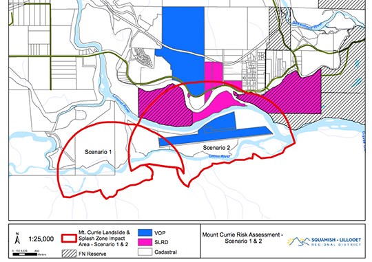
Two scenarios were identified as having the potential for rock avalanches large enough to travel north of the Green and/or Lillooet Rivers, the release said.
In these cases, the rockfalls are predicted to travel over 100 kilometres per hour and involve volumes up to approximately 8 million cubic metres of material.
The chances of either case happening is still relatively low, however.
The SLRD said that chance of that happening are 0.02 per cent or less.
“Due to Mount Currie’s size and the number of source zones for rock avalanches, the Assessment states that engineered mitigation options are not practical,” the release said.
Community information sessions will take place on Jan. 24 at 6:30 p.m. at the Pemberton & District Community Centre and on Jan. 25 at 6:30 p.m. at the Ull’us Community Complex.


