We always get rain in Squamish, so what is the big deal about the rain we have been getting in the series of storms since Friday?
Lisa Ervin, a warning preparedness meteorologist with Environment and Climate Change Canada, says we are getting more than average for this time of year in Squamish.
Typically, Squamish would see about 326 millimetres of rain in all of January.
So far, as of Jan. 31 at 9 a.m., we've seen 418.1 mm.
"That just includes only up until the past hour today, so we're still going to see rain through today," she said.
What is particularly impactful for our region is that we've seen the high freezing levels, she said, and the freezing levels have remained elevated even through the night.
"And that's an unusual weather pattern. Usually, we see a little bit more of a trend [where] levels go up, and then overnight cooling, the freezing levels come down. But with the persistent southerly winds happening over the province right now, the warm air has continuously pumped into the province, and the freezing levels have remained elevated even during the overnight period," she said. “So, you're still seeing mild temperatures, even overnight. And that's contributing to the impact on the snowpack."
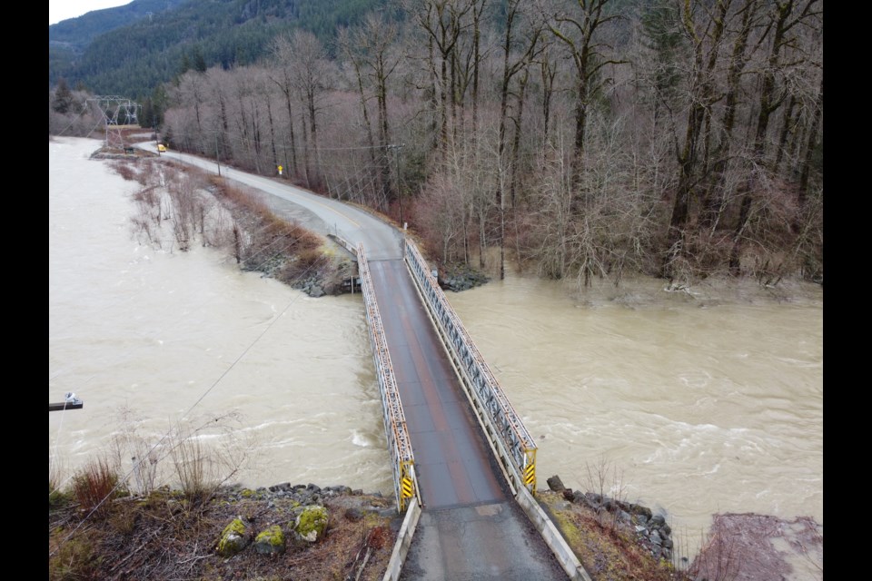
An Environment Canada rainfall warning remains in effect in Squamish for Wednesday.
This applies to Howe Sound, including Squamish.
Near 50 mm of rain is expected.
"Heavy downpours can cause flash floods and water pooling on roads. Localized flooding in low-lying areas is possible," the warning reads.
"Watch for possible washouts near rivers, creeks and culverts."
A special weather statement is also in place for the south coast, including our region.
It is in place from now through the next few days.
It applies to West, North, Inland and East Vancouver Island, Sunshine Coast, Metro Vancouver and the North Shore, including West Vancouver, North Vancouver, and Howe Sound.
"A series of storms is bringing periods of heavy rain to coastal BC. The warm airmass is producing temperatures 5 to 10 degrees Celsius above seasonal," reads the statement.
"Freezing levels will remain around 2,000 metres through midweek. The combination of elevated freezing levels and heavy rain will result in snow melt, in addition to the already heavy rainfall."
The Environment Canada weather station at the Squamish Airport shows it will reach 10 C today and dip to 7 C tonight.
The average high on this day in Squamish is 5.6 C, and the average overnight low is -0.4 C.
The warmest it has been on this day was 13.5 C in 1992.
(On Tuesday, Jan. 30, 2024, it reached a high of 12.4 C, and the overnight low was 7.0 C. )
The coldest it has gotten on this day was -7.6 C in 1985.
The most precipitation we have seen on Jan. 31 (1983 to 2023) was 115.0 mm in 2020.
Thursday is expected to reach a high of 9 C and a low down to 4 C overnight.
Friday, we can expect a high of 5 C and a low down to 0 C.
When can we see the sun?
Ervin said there is some uncertainty of when this current round of rain will end and the sun will appear, noting that the rain and warm air has extended the forecast further out than first thought.
"The current forecast is calling for a mix of sun and cloud on Saturday. And up until then it's either rain, periods of rain, or at least a high chance of rain," she said. "There might be a bit of a slower transition to a real break in the current rainy pattern, but it is on the way. And I do suspect it will happen at some point this weekend. It's just whether that Saturday or Sunday.
DOS response
The District says that residents can report any localized flooding to the 24-hour emergency line at 604-815-4040. The District also has a sandbag station available 24 hours at Brennan Park and users will need to bring their own shovel.
The Squamish Chief is updating this story often as the weather changes.
For up-to-the-minute Squamish weather, go to our Weatherhood page.
Weatherhood also recently launched its app on iOS and Android for phone or tablet devices.
Bookmark squamishchief.com so you can return for more local stories like this. Get Squamish news daily in our free newsletter. Sign up here.


