Some local conservationists are concerned the district is once again considering a transportation route through the Squamish Estuary, which they say would devastate it.
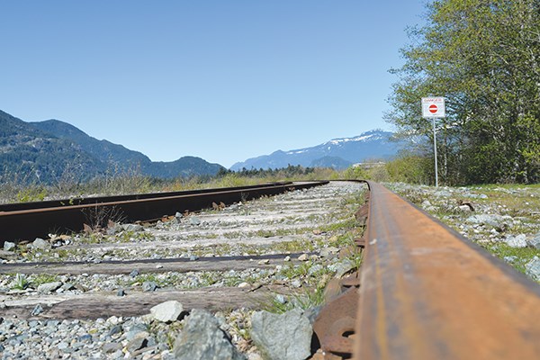
The recently commissioned $99,000 district truck route study will consider, among other options, a Seventh Avenue Connector, which would divert trucks from their current route downtown on Loggers Lane through the Squamish Estuary along the Transportation Corridor. The proposal would see trucks drive along the CN railway south from the intersection of the CN mainline to the CN Rail crossing at Third Avenue.
Environmentalist John Buchanan told The Squamish Chief the idea of putting any road through the estuary “would be worse than two LNG plants” in terms of the damage it would do to the ecosystem.
“Because of the high environmental real estate values that estuaries have, even two local LNG facilities wouldn’t be as bad as losing more of the estuary for a trumped-up so-called truck route,” he said.
Mayor Patricia Heintzman stresses that the connector is just one option the study will investigate and not one she personally favours.
“There still is some interest in that by some councillors and some people in industry,” she said. “What we are trying to make sure is that we do a full analysis to make the best decision.”
This is not a new issue. For more than a decade, as Squamish has grown, representatives of established local industries that need to move goods from the waterfront inland, such as the forest industry and Squamish Terminals, have called for a dedicated truck route.
Squamish Terminals, which has been on the waterfront for 40 years, has been concerned for years with residential expansion in the downtown encroaching on the existing truck route, and causing issues around safety, reliability and efficiency, according to Kim Stegeman-Lowe, vice-president of administration at the terminals.
“Now with the Squamish Oceanfront development moving forward, as well as other development projects in downtown Squamish, it is even more important that the truck route issue is recognized as an important community issue,” said Stegeman-Lowe. “We collectively need a safe, reliable, and efficient truck route. If the various stakeholders work together, we should be able to come up with a sustainable solution, one that we can all live with and be proud of.”
Edith Tobe of the Squamish River Watershed Society asked, given that the Loggers Lane is the designated trucking road, “why is the District of Squamish developing so much park, community space along Loggers Lane on their designated trucking route?”
Heintzman said Loggers Lane was designated a truck route when the area was mostly log sorts.
“Community vision has changed over the years and is looking to make that area more people friendly, more oriented toward people than industry along that stretch.”
The Squamish and District Forestry Association, which primarily funded the Loggers Land truck route in the 1960s, believes an alternative option must be found.
“The plan to locate housing for several thousand new residents on the Oceanfront. The 1999 Squamish Estuary Management Plan (SEMP) includes an expansion of the Transportation Corridor through the estuary, “for future road and rail transportation if and when needed,” the plan states.
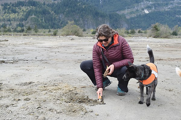
“We identified all the lands to the west of the Transportation Corridor… as being within the wildlife management area and being protected,” said Tobe, who was involved in the creation of the 1999 plan. “The Transportation Corridor and everything east… is still extremely important estuary habitat, but it doesn’t have the same level of protection.”
Tobe said the original intention of the SEMP was never to put a road through the Transportation Corridor.
“It was never even conceived back then for trucking or a road for anything other than the Squamish Terminals,” she said.
Tobe, a biologist, said with more science on climate change and a better collective understanding of the value of estuaries, the time has perhaps come to revisit the 1999 document.
As a way of helping people understand the value of the estuary, the Squamish River Watershed Society is currently working on establishing a Blue Carbon Protocol – identifying carbon sequestering potential within the Squamish Estuary.
“So if we infill any of the estuary, how many carbon credits are we losing?” Tobe said. “Bring it back to dollars and cents.”
She said another glaring issue is the cost of a Seventh Avenue Connector, which would be in the tens of millions of dollars, according to previous district estimates.
Buchanan has a truck route option he has floated for years, and that Tobe supports, to take trucks right off the highway.
“Do what makes sense and build a direct exit from the highway from Vancouver to a new bridge over the Mamquam Blind [Channel],” he said. “Take this thought even further and build a culverted land bridge over the Mamquam Blind and then open the Cattermole [Slough] waterway as the new navigation channel into the Mamquam Blind.”
In its draft Integrated Flood Management Plan, the district also contemplates a sea dike along the Transportation Corridor with a possible road on top of it that would serve as the truck route to downtown’s industries. The current flood dike is along Sixth Avenue and it is inadequate protection, according to district studies.
Mayor Heintzman said there may be a Seventh Avenue alignment that minimizes the impact on the estuary, “and actually would make it so we can change where the dike went, period.”
Tobe vehemently objects to a dike being along the Transportation Corridor compared with the expanded road and rail option.
“If they put a flood dike to the west of the bridge pond on that train track, they are going to lose all that beautiful flood storage that the bridge pond currently provides,” said Tobe. “I would like the district to consider upping the Sixth Avenue Flood dike so that it allows all of the estuary, all of the lands to the west of Sixth Avenue, to act as flood storage, which costs us nothing, because the estuary is a natural sponge.”