This research project is exploring geothermal potential near Mount Meager
As Canada looks towards new forms of renewable energy to help slow the pace of climate change, geothermal energy, where available, is worth exploring.
However, here in the Great White North, no electricity is currently being generated from geothermal power—despite the existence of a volcanic belt along B.C.'s South Coast.
But now, a team of researchers has set up shop at Mount Meager, a single volcano northwest of Pemberton, to assess just how much geothermal potential the region really has.
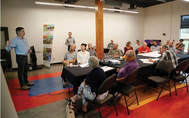
The overall goal of the Garibaldi Geothermal Volcanic Belt Assessment Project, a combined effort between Geoscience BC and the Geological Survey of Canada, is to reduce the exploration risk into this renewable energy source by increasing knowledge of what's happening beneath the surface, said Dr. Stephen Grasby, a senior research scientist with the Geological Survey of Canada during an open house held at the Pemberton & District Community Centre on Thursday, July 11.
"If we want to encourage the use of one of the best forms of renewable power and clean energy in Canada, we have to make them look attractive to industry, and to do that, we have to reduce the risk of exploration," he explained.
A team of 24 researchers, comprised of professors, post doctoral, PhD, masters and undergraduate students from six institutions are participating in the project.
In simple terms, geothermal energy uses steam, converted from hot water found deep in the Earth, to power a turbine, which then generates electricity, explained Grasby to the crowd of about 25 attendees.
It's cleaner and more consistent compared to solar and wind power, operates at a high capacity, and, depending on the temperature of the resource, significantly cheaper.
"The higher the temperature of the resource, the lower the cost of the power it produces," said Grasby. Particularly when the water collected is found to be 200 degrees Celsius or hotter, "You're looking at very cheap power compared to other sources."
With all those benefits, it should come as no surprise that this isn't the first time geothermal potential has been explored around the Garibaldi Volcanic Belt.
Beginning in the mid-1970s, the Canadian government began investigating alternative forms of energy, including through an active federal geothermal research program. One of the areas that program focused on was Mount Meager, where Natural Resources Canada joined forces with BC Hydro to drill a series of research wells, Grasby said.
While researchers discovered steam and were able to produce power, permeability was an issue. "They found hot water, up to 240 degrees Celsius—this is a world-class thermal resource that was discovered—but the problem was that the flow rate to the surface wasn't high enough to justify the cost" of installing full geothermal power facilities, said Grasby.
"Canada has enormous [geothermal] potential, we've just been negligent in exploring for it and making use of this potential. It's not that people haven't tried over time, rather it's just that there's been a whole set of different barriers that have limited interest in exploring for geothermal in Canada," he said.
But when researchers decided to revisit the West Coast's geothermal potential by amalgamating prior data from a variety of sources, they found signs pointing towards "a map-able, permeable zone, that looks like it's interconnected," said Carlos Salas, executive vice president and chief scientific officer at Geoscience BC. "This myth [about a lack of water flow] that's been perpetrated through history might not be true."
To that end, the current project is consolidating the knowledge already collected about geothermal potential underneath Mount Meager and looking to find out more with modern research techniques.
Those will include geological mapping—determining rock type, faults and folds that can show researchers where and when any volcanic events occurred—passive seismic scans to track the speed of earthquake waves deep inside of Mount Meager, magnetotellurics (or MT) surveys, where researchers bury magnetic field sensors and electrodes to measure magnetic and electric field variations, as well as a gravity survey to measure "minute changes" in gravity at different locations.
In addition to showing researchers how to find the permeable zones and hot water necessary to produce geothermal power, these research methods will function to help the project accomplish its goal of reducing exploration risk while painting a picture of what's going on underneath Meager's surface.
For example: where and at what depth the volcano's magma chamber might be located.
"[Mount Meager] is steaming today, we can see vents and steam, but no one even knows if [the chamber is] 10 kilometres deep or if it's right near the surface and about to erupt," Grasby said.
To that end, the project, "will help with understanding the geothermal side but it will also be invaluable for understanding some of the risks associated with living next to a volcano," he added.
For more information about the project visit geosciencebc.com/projects/2018-004/.
For the original story go here.


