An “exceptional climate change event” is forecast to push temperatures well above seasonal averages across B.C. this week and could lead to spike in wildfire risk, a new analysis warns.
Scientists at the U.S. research group Climate Central have released models showing a warm spell stretching May 1 to 5 will be made five times more likely due to climate change.
Temperatures over the five-day period are expected to climb between five and 10 degrees Celsius above the historical average going back to 1991, according to Andrew Pershing, director of climate science at Climate Central.
“We were looking at this and getting flashbacks with some of the patterns that we were seeing last year,” Pershing said.
“This was how we saw the [wildfire] season kicking off last year.”
Climate Central’s analysis is based on a pool of historical weather data. That data is fed into a peer-reviewed process that compares observed temperature data with models that show a counterfactual world, one where human-caused global warming never happened and the weather behaves on its own.
The modelling is combined into a public-facing Climate Shift Index (CSI), a near real-time rapid attribution tool showing the likelihood climate change is influencing current global temperature patterns. The resulting five-step scale ranges from a yellow CSI +1, which means climate change has made temperatures 1.5 times more likely — to CSI +5, where red shading shows climate warming has increased the odds of hot weather by a factor of five.
'Pulse of heat'
Pershing said the latest analysis came out of his team's weekly global scans that look for places where climate change is warping regional weather patterns. When they looked at B.C. this week, the climate scientist said they saw a “pulse of heat” light up the map.
Brian Proctor, a meteorologist with Environment and Climate Change Canada who didn't take part in the Climate Central analysis, said computer weather models he has seen suggest temperatures rising between three to five degrees Celsius across some parts of B.C.
Proctor said last year’s May heat wave hit later, harder and extended over a wider area than what’s expected over the coming days in B.C. In the second week of May 2023, temperatures spiked up to 15 C above normal across B.C. and into Alberta and the Northwest Territories.
“This year, we’re seeing some warming coming,” he said. “What the potential impacts are depends on how the weather plays out.”
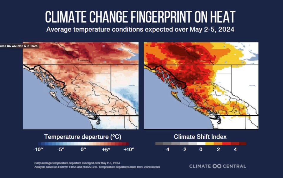
Over the next several days, Climate Central’s modelling paints a large slice of the map of B.C. in deep red, spanning the Alaska border to the northern half of Vancouver Island.
Some of the most unusual temperatures are expected to be seen in Stikine and Kitimat-Stikine, the Central Coast, Bulkley-Nechako, and the west sides of the Cariboo, Peace River and Northern Rockies. The interior of the province is expected to see hotter than average temperatures made two to three times more likely due to climate change, says the analysis.
And in B.C.’s southern cities, more than 3.8 million people are also expected to face at least one day this week where human-caused climate change makes the warm temperatures at least twice as likely.
Little precipitation in sight
The warning comes as B.C. faces snowpack levels 63 per cent of normal, the lowest in half a century. It’s a problem felt nearly everywhere in the province because melting snow helps moisten land and fill waterways.
Then there's drought, which has become a multi-year problem in many parts of the province. In the three years between January 2021 and December 2024, Kelowna recorded just 600 of the 1,100 millimetres of precipitation it usually gets — a 45 per cent drop from normal levels, said Proctor.
An upper level trough set to sit across B.C. is not expected to bring much precipitation to alleviate those conditions, Proctor said. Instead, it could destabilize the atmosphere in a way that will lead to more lightning strikes.
“If we see a lot of convection but not a lot of moisture reaching the surface… the forest floor is going to be very receptive for lightning strikes,” said the Environment Canada meteorologist. “We’re in a very tenuous situation from a wildfire point of view.”
Fire service gets ready as temperatures climb
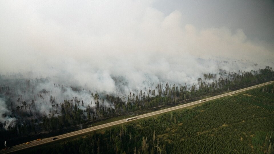
There are currently 107 active wildfires burning in B.C., with long-range forecasts suggesting “a high potential for an active spring wildfire season in British Columbia,” according to the BC Wildfire Service.
Fire information officer Taylor Colman said the service is getting ready for a big season.
“We are heading into a warming, drying trend,” she said. “We are going into it with increased drought.”
“The fuels are going to become drier, more susceptible to ignition.”
Environment Canada’s fire weather index shows fire intensity will reach its highest levels Friday across a wide band of interior British Columbia. After that, Proctor said even more heat is expected in the latter half of May. But how that plays out “is going to depend on the weather of the day.”
“We don't know what's going to happen as the weather rolls through the region,” added Pershing.
“But what we want to do is highlight that the things that you see over the next few days are part of the climate change story.”
Correction: A previous version of this story showed a map labelled "average temperatures" but showed instead the climate change influence on forecast minimum temperatures. It has been corrected.


