It couldn't be a more timely report.
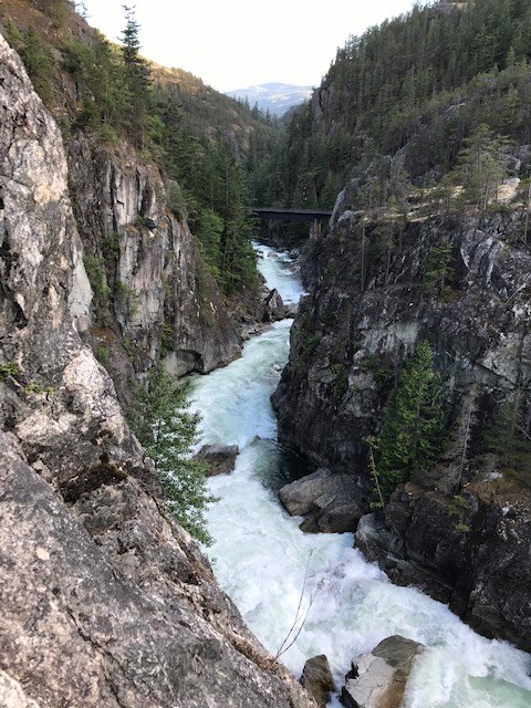
As the Fraser Valley continues to grapple with the impact of its November floods and in the wake of December evacuation alerts for the Squamish Lillooet Regional District (SLRD) Area C, comes the "Flood Hazard Mapping and Risk Assessment — Upper Paradise Valley," report.
“As with any hazard and risk assessment report, residents and property owners should take the time to read the report and consider the findings in relation to where their property is located,” Sarah Morgan, SLRD’s director of protective services told The Squamish Chief.
The property lots in the study area are all Crown leasehold parcels.
Ebbwater Consulting Inc. completed the study, which includes mapping and risk assessments of both hydrological (water) and geomorphological (landform) hazards.
“On the SLRD side, these results contribute to our emergency response planning, advocacy with the province in terms of climate action and disaster risk reduction, and also contribute to the total body of knowledge about hazards and risks in the SLRD, which is information that is included in policy and planning documents such as Official Community Plans,” said Morgan.
This flood assessment project completes the assessment of the Cheakamus River floodplain from Highway 99 at the Daisy Lake Dam in the north, to the District of Squamish municipal boundary in the south of the study area.
The high-level findings were recently discussed in an online SLRD online presentation.
"The goal was really to understand the risks, the hazards and to assess risk at a very high level for the upper Paradise Valley portion of the Cheakamus River and then the project outputs will support mitigation planning and emergency management for the SLRD," said Robert Larson, of Ebbwater Consulting during the presentation.
Key takeaways
The report found that the total building value exposed to flood in the study area ranges from $79 million to $82 million. When fluvial geohazards are considered, including damage to land values, with a moderate flood magnitude, the consequences increase to $98 million — a 20% increase.
Eight facilities, primarily electrical power stations, are exposed in the study area to the very low flood magnitude and one additional facility is exposed to the moderate flood magnitude or higher.
Though a small portion of road is within flood danger, the consultants noted that any amount of road that is unusable due to a flood can have a significant impact.
Approximately one kilometre of road is vulnerable to the moderate flood magnitude or higher flood. When fluvial geohazards are considered with the moderate flood magnitude, the length of exposed roads increases by approximately 200 metres. Out of the four river crossings in the project area, only the pedestrian crossing would be flooded, and this occurs with a high flood magnitude or higher, the report states.
The consultants said the SLRD should be aware that the risk from very low flood magnitude — almost certain, small floods — is generally higher than the risk for the moderate and high flood magnitudes — more rare, larger floods
"This means that, cumulatively over time, the damages from small events can potentially add up to be larger than those from larger events that governments typically focus on for flood mitigation," the report reads.
It also notes that geohazards — fluvial processes (such as erosion, sedimentation, and river migration), and hillslope processes (such as debris floods and debris flows) — "are interlinked with flood hazards, and damages stemming from them can be substantial."
The report also warns that with climate change, flooding is only predicted to get worse.
"Although it is difficult to project future flows under climate change, the flood flows that have
been experienced in the past are getting more frequent and larger with time. Climate change
conditions will also exacerbate the frequency and magnitude of geohazards," reads the report.
Recommendations
The report recommended the SLRD make the Flood and Geohazards Mapping Products public, which the regional district has done.
It also recommends that the SLRD undertake more comprehensive studies.
"Climate and hydrometric monitoring should be expanded to obtain more accurate and representative data across the region, and post-flood event measurements need to be obtained more systematically to facilitate flood model calibration," the report states.
It further recommends the regional district work with regional partners, including First Nations, and translate the information into land use policies.
It recommends working on helping property owners make themselves more flood resilient.
It also recommends mitigation strategies be researched.
"The planning process would require engagement with interested and affected parties. It will be critical to engage with the community to understand the values that drive sentiments in the area," the report reads.
It also recommends that the regional district looks at funding opportunities “to effectively implement mitigation options following a flood."
High level
Chessy Knight, president of the Squamish River Watershed Society, read over the report and told The Chief it should be considered very high level.
She noted the report used numbers taken from the Cheakamus River at Brackendale flow gauge, not natural flows.
"So everything that they're kind of saying about the Brackendale flows is an underestimate," she said.
She also wishes the report had taken into account the impact a breach of the Garibaldi Lake barrier could have downstream, including on the BC Hydro dam.
"That barrier is located up the watershed of Rubble Creek; Rubble Creek comes into the Cheakamus about a kilometre below the dam. So if that thing really goes, it would have been blocking the Cheakamus. If it blocks the Cheakamus, it's going to back up over the dam. That is a significant geohazard," she said, noting not including this is a significant limitation of the report.
Larson noted BC Hydro has done its own study and considered a failure from Daisy Lake Dam, so that was not considered part of this analysis.
BC Hydro operations were not considered directly in the report.
"Our model is based on flows coming down from the Cheakamus River from the Daisy Lake Reservoir, so in that sense it implicitly accounts for the regulation of the reservoir, but we kept things simple deliberately knowing that things could change in the future with a number of factors like flow regulation, like climate change, like land-use change," Larson said.
Key takeaways
Larson noted that what the study found was that there is a relatively small number of people who are exposed to the very low flood magnitude [6% of the population], but this number jumps up to about 40% of the total number of people in the project area are exposed to the moderate flood scenario.
Morgan told The Chief that within the study area there is quite a small population around 35 people based on the 2016 census, but the study contributes to the understanding of the whole watershed, which is a larger population downstream of the study area, and, in this way, the findings contribute to the overall flood risk assessment and mapping for the area, she said.
Larson highlighted the impact of climate change in the future.
"We know that in general, these events are going to get worse. So not just the small events, but the larger events as well. We don't have a good grasp in terms of how much, but we definitely know the direction of change,” he said.
He also noted that geohazards are "interlinked with flood hazards, and they can cause substantial additional damage and this is also linked to climate change in that it will exacerbate the incidence of these geohazards," he added. "We know that future hazard [are] increasing due to climate change. So, that gives us the opportunity to reduce risk through exposure and vulnerability."
**Please note, this story has been corrected since it was first posted to more accurately define what the report meant by geohazards. They meant: fluvial processes (such as erosion, sedimentation, and river migration), and hillslope processes (such as debris floods and debris flows).


